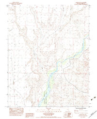
1983 Map of Overton NE
USGS Topo · Published 1983About this map
Virgin Valley forms a prominent corridor through this section of Clark County, where the desert landscape is defined by the contrast between high plateaus and the river bottom. The Mormon Mesa dominates the western portion of the map, presenting a broad, elevated surface that drops sharply toward the lowlands. Central to this area is the Overton Virgin Wildlife Management Area, which tracks the course of the Virgin River as it moves south. This 1983 provisional survey captures the geography of the region before significant modern expansion, detailing natural drainage patterns like Halfway Wash and the established township and range lines. The map reveals a transition from arid mesa tops to the riparian environment of the valley, providing a clear view of the land management and topographical boundaries in place during the early 1980s.
Find a feature on this map
8 named features on this map. Tap any name to fly to it.
Don’t see what you’re looking for? This feature index may not catch every label — zoom into the map to look around manually.
Map Details
Editions of this 1983 Overton NE Map
This is the sole edition of this map. No revisions or reprints were ever made.
Other maps of this area

1886 · Saint Thomas
USGS Topo · 1:250,000

1893 · Saint Thomas
USGS Topo · 1:250,000

1954 · Las Vegas
USGS Topo · 1:250,000

1957 · Las Vegas
USGS Topo · 1:250,000

1957 · Mesquite
USGS Topo · 1:62,500

1958 · Virgin Peak
USGS Topo · 1:62,500

1958 · Overton
USGS Topo · 1:62,500

1959 · Las Vegas
USGS Topo · 1:250,000

1962 · Las Vegas
USGS Topo · 1:250,000
1969 · Moapa Peak
USGS Topo · 1:24,000