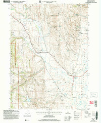
2005 Map of Ovid
USGS Topo · Published 2007About this map
Ovid and the surrounding Bear Lake Valley settlements appear here as they were organized at the turn of the 21st century. This landscape is defined by a series of small, rural communities situated along the western edge of the valley floor, where the foothills of the Cache National Forest meet the drainage of Ovid Creek. Genealogists will find critical local landmarks including the Ovid Cem, Liberty Cem, and Lanark Cem, which serve as anchors for the historic family names of the region.
Find a feature on this map
44 named features on this map. Tap any name to fly to it.
Don’t see what you’re looking for? This feature index may not catch every label — zoom into the map to look around manually.
Map Details
Editions of this 2005 Ovid Map
This is the sole edition of this map. No revisions or reprints were ever made.
Other maps of this area

1909 · Montpelier
USGS Topo · 1:125,000

1911 · Montpelier
USGS Topo · 1:125,000

1915 · Preston
USGS Topo · 1:96,000

1918 · Preston
USGS Topo · 1:125,000

1955 · Preston
USGS Topo · 1:250,000

1958 · Preston
USGS Topo · 1:250,000

1962 · Preston
USGS Topo · 1:250,000

1967 · Montpelier
USGS Topo · 1:24,000

1967 · Paris
USGS Topo · 1:24,000

1967 · Ovid
USGS Topo · 1:24,000