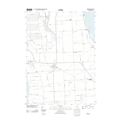
2013 Map of Ovid
USGS Topo · Published 2013About this map
Ovid serves as the central hub of this Seneca County landscape, situated on the narrow finger of land between the deep waters of Seneca Lake to the west and Cayuga Lake to the east. The village structure is well-defined by its historic burial grounds, including the Old Ovid Village Cem and Union Cem. To the north, the sprawling footprint of the Seneca Army Depot dominates the terrain, featuring an extensive grid of tactical roads like Bundle Ammo Pack Rd and S Patrol Rd. Along the eastern lakeshore, small settlements like Sheldrake Springs and Poplar Beach are carved out by seasonal drainages such as Bloomer Cr and Powell Cr. The map captures a blend of military infrastructure, agricultural crossroads at Hayt Corners and Coan Corners, and lakeside recreation at Sned Acres Family Campground.
Find a feature on this map
107 named features on this map. Tap any name to fly to it.
Don’t see what you’re looking for? This feature index may not catch every label — zoom into the map to look around manually.
Map Details
Editions of this 2013 Ovid Map
This is the sole edition of this map. No revisions or reprints were ever made.
Other maps of this area

1899 · Auburn
USGS Topo · 1:62,500

1902 · Geneva
USGS Topo · 1:62,500

1902 · Genoa
USGS Topo · 1:62,500

1902 · Ovid
USGS Topo · 1:62,500

1902 · Auburn
USGS Topo · 1:62,500

1942 · Ovid
USGS Topo · 1:31,680

1942 · Dundee
USGS Topo · 1:24,000

1942 · Lodi
USGS Topo · 1:24,000

1942 · Sheldrake
USGS Topo · 1:24,000

1942 · Trumansburg
USGS Topo · 1:24,000