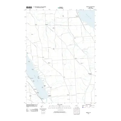
2010 Map of Owasco
USGS Topo · Published 2010About this map
Skaneateles Lake and Owasco Lake anchor this 2010 study of the Finger Lakes region, where the steep eastern slopes of the Owasco basin meet a high agricultural plateau. The landscape is defined by the deep carving of Dutch Hollow Brook, which flows through a valley scattered with crossroads settlements like Niles and Valentine Corners. This area retains a strong agricultural and residential character, evidenced by larger operations such as Twin Birch Farms and Folls Flower Farm.
Find a feature on this map
87 named features on this map. Tap any name to fly to it.
Don’t see what you’re looking for? This feature index may not catch every label — zoom into the map to look around manually.
Map Details
Editions of this 2010 Owasco Map
This is the sole edition of this map. No revisions or reprints were ever made.
Other maps of this area

1898 · Moravia
USGS Topo · 1:62,500

1899 · Auburn
USGS Topo · 1:62,500

1899 · Skaneateles
USGS Topo · 1:62,500

1902 · Skaneateles
USGS Topo · 1:62,500

1902 · Moravia
USGS Topo · 1:62,500

1902 · Genoa
USGS Topo · 1:62,500

1902 · Auburn
USGS Topo · 1:62,500

1942 · Genoa
USGS Topo · 1:24,000

1943 · Moravia
USGS Topo · 1:31,680
1943 · Genoa
USGS Topo · 1:31,680