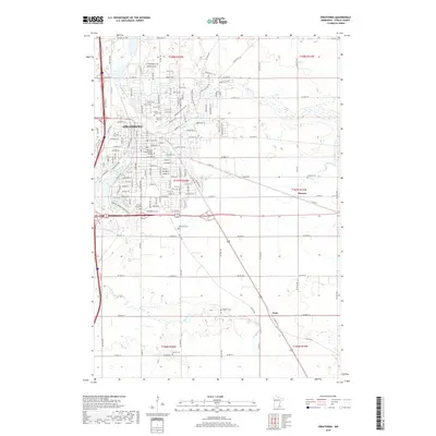
2019 Map of Owatonna
USGS Topo · Published 2019About this map
Straight River and Maple Cr converge in the city of Owatonna, the primary settlement of this Steele County region. The landscape is marked by a deep concentration of local heritage sites, including the Pillsbury Baptist-Bible College and several denominational burial grounds such as Saint John Cem, Sacred Heart Cem, and the Bohemian Cem. Outside the city limits, the terrain transitions into a grid of rural roads and watercourses like Turtle Cr, connecting smaller communities like Havana and Pratt. To the south of the urban center, Kaplan's Woods Singletrack provides a dedicated recreational area along the river. The map also reveals scattered family and community landmarks such as Degner Cem and Danish Cem, which offer significant value for genealogists tracing the ethnic settlement patterns of this Minnesota prairie region.
Find a feature on this map
47 named features on this map. Tap any name to fly to it.
Don’t see what you’re looking for? This feature index may not catch every label — zoom into the map to look around manually.
Map Details
Editions of this 2019 Owatonna Map
This is the sole edition of this map. No revisions or reprints were ever made.
Other maps of this area

1953 · Saint Paul
USGS Topo · 1:250,000

1954 · Mason City
USGS Topo · 1:250,000

1957 · Mason City
USGS Topo · 1:250,000

1958 · Mason City
USGS Topo · 1:250,000

1959 · Saint Paul
USGS Topo · 1:250,000

1962 · Medford East
USGS Topo · 1:24,000

1962 · Owatonna
USGS Topo · 1:24,000

1962 · Moland
USGS Topo · 1:24,000

1962 · Owatonna SE
USGS Topo · 1:24,000

1962 · Saco
USGS Topo · 1:24,000