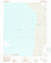
1987 Map of Owens Lake
USGS Topo · Published 1987About this map
Owens Lake dominates this 1980s landscape, characterized by a vast dry basin marked by extensive systems of levees and areas noted as subject to inundation. This provisional survey by the U.S. Geological Survey and the City of Los Angeles documents the industrial and environmental state of the Owens Valley at this time. Industrial activity is evident in the south, where an Open Pit Mine and several Open Pit Mines are situated near a network of protective embankments. The eastern margins of the lake bed are punctuated by natural springs, while the western edge reaches toward the alluvial fans of East Cottonwood. Transportation is limited to rugged 4wd tracks, reflecting the specialized utility and challenging nature of the terrain during this era of water management and resource extraction.
Find a feature on this map
11 named features on this map. Tap any name to fly to it.
Don’t see what you’re looking for? This feature index may not catch every label — zoom into the map to look around manually.
Map Details
Editions of this 1987 Owens Lake Map
This is the sole edition of this map. No revisions or reprints were ever made.
Other maps of this area

1905 · Olancha
USGS Topo · 1:125,000

1907 · Olancha
USGS Topo · 1:125,000

1907 · Mt. Whitney
USGS Topo · 1:125,000

1908 · Ballarat
USGS Topo · 1:250,000

1913 · Ballarat
USGS Topo · 1:250,000

1919 · Mt. Whitney
USGS Topo · 1:125,000

1937 · Mt. Whitney
USGS Topo · 1:125,000

1948 · Death Valley
USGS Topo · 1:250,000

1948 · Fresno
USGS Topo · 1:250,000

1950 · New York Butte
USGS Topo · 1:62,500