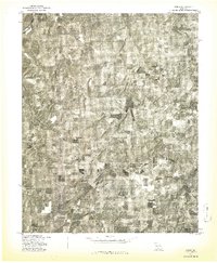
1977 Map of Owens
USGS Topo · Published 1977About this map
The settlement of Owens sits at the heart of this Missouri landscape, which is defined by the winding course of the Gasconade River cutting through the northwestern corner. Based on aerial photography from April 1977, this orthophotograph reveals a complex pattern of agriculture and forestry typical of this portion of Wright County. The imagery shows a mosaic of cleared pastures and dense woodlands, providing a clear view of the rural homesteads and farm roads as they existed during the late 1970s. Because this is an advance print produced in cooperation with the Soil Conservation Service, it captures the raw textures of the terrain without the distraction of heavy cartographic symbols, making it a valuable tool for understanding land use and property boundaries in the Owens area during this period.
Find a feature on this map
2 named features on this map. Tap any name to fly to it.
Don’t see what you’re looking for? This feature index may not catch every label — zoom into the map to look around manually.
Map Details
Editions of this 1977 Owens Map
This is the sole edition of this map. No revisions or reprints were ever made.
Other maps of this area

1931 · Manes
USGS Topo · 1:48,000

1941 · Manes
USGS Topo · 1:62,500

1943 · Manes
USGS Topo · 1:62,500

1951 · Norwood
USGS Topo · 1:24,000

1951 · Mountain Grove South
USGS Topo · 1:24,000

1951 · Mountain Grove North
USGS Topo · 1:24,000

1951 · Owens
USGS Topo · 1:24,000

1951 · Mansfield NE
USGS Topo · 1:24,000
1951 · Mansfield
USGS Topo · 1:24,000

1951 · Mountain Grove
USGS Topo · 1:62,500