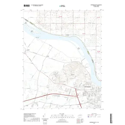
2019 Map of Owensboro West
USGS Topo · Published 2019About this map
Owensboro and its western outskirts are defined by the wide sweep of the Ohio River, which forms the northern boundary against Indiana. The landscape transition from the river bottomlands to the interior is marked by the Bon Harbor Hills and the meandering path of Katie Meadow Slough. Settlement patterns are clear along old transit corridors like Griffith Station Rd, connecting established communities such as Stanley and Griffith. For genealogists, the map provides precise locations for several burial sites, including Fern Hill Cem and Lancaster Cem near the settlement of Fern Hill, as well as the Arnold Cem and Alexander Cem further north. The river environment is dotted with named features like Little Hurricane Island, Bunches Bend, and French Island Number 1, reflecting the area’s long-standing reliance on the Ohio for transport and commerce.
Find a feature on this map
131 named features on this map. Tap any name to fly to it.
Don’t see what you’re looking for? This feature index may not catch every label — zoom into the map to look around manually.
Map Details
Editions of this 2019 Owensboro West Map
This is the sole edition of this map. No revisions or reprints were ever made.
Other maps of this area

1901 · Owensboro
USGS Topo · 1:62,500

1905 · Newburg
USGS Topo · 1:62,500

1906 · Sutherland
USGS Topo · 1:62,500

1908 · Calhoun
USGS Topo · 1:62,500

1951 · Yankeetown
USGS Topo · 1:24,000

1952 · Owensboro East
USGS Topo · 1:24,000

1952 · Rockport
USGS Topo · 1:24,000

1952 · Owensboro West
USGS Topo · 1:24,000

1952 · Reed
USGS Topo · 1:24,000

1953 · Sutherland
USGS Topo · 1:24,000