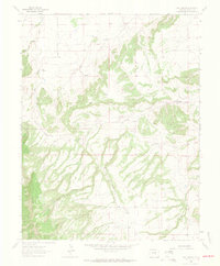
1963 Map of Owl Canyon
USGS Topo · Published 1965About this map
The San Isabel National Forest dominates the southwestern corner of this Colorado landscape, where the high desert terrain transitions into the foothills of the Rockies. The drainage network is particularly dense, defined by the winding paths of North Red Creek, South Red Creek, and Rush Creek as they cut through the arid soil. Human presence is sparse, marked primarily by the unimproved tracks of Siloam Road and Red Creek Road, which provided vital access for early ranchers and mineral prospectors.
Find a feature on this map
12 named features on this map. Tap any name to fly to it.
Don’t see what you’re looking for? This feature index may not catch every label — zoom into the map to look around manually.
Map Details
Editions of this 1963 Owl Canyon Map
2 editions found
Other maps of this area

1889 · Canon City
USGS Topo · 1:125,000

1891 · Pueblo
USGS Topo · 1:125,000

1892 · Canon City
USGS Topo · 1:125,000

1894 · Pueblo
USGS Topo · 1:125,000

1896 · Pueblo
USGS Topo · 1:125,000

1897 · Pueblo
USGS Topo · 1:125,000

1954 · Pueblo
USGS Topo · 1:250,000

1957 · Pueblo
USGS Topo · 1:250,000

1958 · Pueblo
USGS Topo · 1:250,000
1959 · Florence SE
USGS Topo · 1:24,000