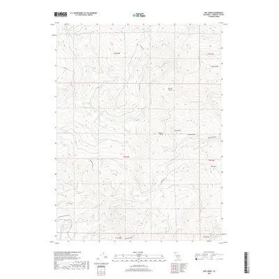
2018 Map of Owl Creek
USGS Topo · Published 2018About this map
Yager Creek and its many tributaries, including the N Fork Yager Cr and Middle-Fork Yager Cr, dominate this section of the Humboldt County timberlands. The landscape is defined by its steep ridges and isolated clearings, most notably McCord Prairie and Bootjack Prairie. Industrial access is evident through a network of specialized routes such as Palco Rd and the Louisiana Pacific Logging Rd, which snake through the drainages of Hely Cr and Lawrence Cr. These logging roads reflect the area's long-standing connection to the Pacific Lumber Company and Louisiana-Pacific operations. To the south, the terrain descends toward the Van Duzen River valley, while prominent heights like Black Butte and Bald Jesse provide significant landmarks for navigating this densely forested interior.
Find a feature on this map
35 named features on this map. Tap any name to fly to it.
Don’t see what you’re looking for? This feature index may not catch every label — zoom into the map to look around manually.
Map Details
Editions of this 2018 Owl Creek Map
This is the sole edition of this map. No revisions or reprints were ever made.
Other maps of this area
1919 · Glynn
USGS Topo · 1:62,500
1921 · Dyerville
USGS Topo · 1:62,500
1922 · Kneeland
USGS Topo · 1:62,500
1944 · Fortuna
USGS Topo · 1:62,500
1949 · Eureka
USGS Topo · 1:250,000
1949 · Weott
USGS Topo · 1:62,500
1950 · Iaqua Buttes
USGS Topo · 1:62,500
1950 · Scotia
USGS Topo · 1:62,500
1951 · Scotia
USGS Topo · 1:62,500
1951 · Weott
USGS Topo · 1:62,500