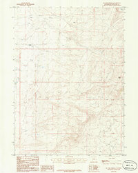
1986 Map of Ox Yoke Springs
USGS Topo · Published 1986About this map
Ox Yoke Springs and Indian Spring anchor this high-desert landscape in Sweetwater County, Wyoming, as it was recorded during the mid-1980s. The terrain is defined by an expansive system of Sand Dunes that shift across the high plains, interrupted only by the seasonal drainage of Morrow Creek in the northeastern corner. This area represents a characteristic Western corridor of public land management, where natural water sources were the primary landmarks for navigation and survival in an otherwise arid environment. Evidence of human infrastructure is minimal, consisting primarily of rough 4wd tracks and a major Trans Line cutting through the southeastern corner, reflecting the region's role as a transit zone for energy and utilities rather than a site for permanent settlement. This survey captures the remote character of the Red Desert region before the widespread expansion of modern resource extraction.
Find a feature on this map
10 named features on this map. Tap any name to fly to it.
Don’t see what you’re looking for? This feature index may not catch every label — zoom into the map to look around manually.
Map Details
Editions of this 1986 Ox Yoke Springs Map
This is the sole edition of this map. No revisions or reprints were ever made.
Other maps of this area

1954 · Rock Springs
USGS Topo · 1:250,000

1955 · Lander
USGS Topo · 1:250,000

1958 · Lander
USGS Topo · 1:250,000

1958 · Rock Springs
USGS Topo · 1:250,000

1958 · Essex Mountain
USGS Topo · 1:62,500

1958 · Boars Tusk
USGS Topo · 1:62,500

1958 · Tule Butte
USGS Topo · 1:24,000

1961 · Lander
USGS Topo · 1:250,000

1962 · Rock Springs
USGS Topo · 1:250,000

1968 · Eden Reservoir East
USGS Topo · 1:24,000