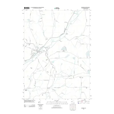
2013 Map of Oxford
USGS Topo · Published 2013About this map
Oxford serves as the focal point of this Chenango County landscape, situated along the winding banks of the Chenango River. The village layout is densely detailed, featuring the State Street Bridge and a cluster of local landmarks including the Post Office and several historic burial grounds like State Street Cem and Saint Joseph's Cem. This 2013 survey reflects a deeply rooted rural community where family names and farmsteads define the outlying terrain. To the north, Many Maples Farm and Mason Packer Cem sit among the hills, while the southern reaches are marked by Walker Corners and South Oxford. The area’s hydrology is well-defined by numerous tributaries such as Eddy Brook and Shapley Brook, alongside local water bodies like Lake Gerry and McCall Pond. The presence of numerous small cemeteries, including Blackman Cem and Rounds Cem, provides significant value for those researching regional family history and the distribution of early settlements.
Find a feature on this map
123 named features on this map. Tap any name to fly to it.
Don’t see what you’re looking for? This feature index may not catch every label — zoom into the map to look around manually.
Map Details
Editions of this 2013 Oxford Map
This is the sole edition of this map. No revisions or reprints were ever made.
Other maps of this area

1902 · Coventry
USGS Topo · 1:62,500

1903 · Norwich
USGS Topo · 1:62,500

1904 · Oxford
USGS Topo · 1:62,500

1910 · New Berlin
USGS Topo · 1:62,500

1912 · New Berlin
USGS Topo · 1:62,500

1915 · Unadilla
USGS Topo · 1:62,500

1918 · Unadilla
USGS Topo · 1:62,500

1943 · Sidney
USGS Topo · 1:24,000

1943 · Holmesville
USGS Topo · 1:24,000

1943 · Norwich
USGS Topo · 1:24,000