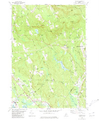
1980 Map of Oxford
USGS Topo · Published 1981About this map
Hebron Public Lands and the historic campus of Hebron Academy define the eastern highlands of this 1980 survey. The landscape transitions from the peaks of Streaked Mtn and Singepole Mtn down toward the Little Androscoggin River valley, where the village of Oxford and the settlement at Welchville are situated. The presence of the Canadian Road and the Old Railroad Grade alongside the river indicates a history of vital transport corridors through the valley floor.
Find a feature on this map
93 named features on this map. Tap any name to fly to it.
Don’t see what you’re looking for? This feature index may not catch every label — zoom into the map to look around manually.
Map Details
Editions of this 1980 Oxford Map
2 editions found
Other maps of this area

1896 · Norway
USGS Topo · 1:62,500

1908 · Poland
USGS Topo · 1:62,500

1911 · Bryant Pond
USGS Topo · 1:62,500

1911 · Buckfield
USGS Topo · 1:62,500

1913 · Buckfield
USGS Topo · 1:62,500

1914 · Bryant Pond
USGS Topo · 1:62,500

1940 · Poland
USGS Topo · 1:62,500

1942 · Buckfield
USGS Topo · 1:62,500

1942 · Bryant Pond
USGS Topo · 1:62,500

1942 · Poland
USGS Topo · 1:62,500