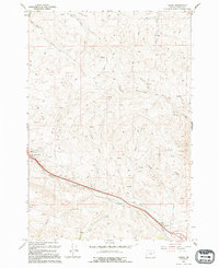
1994 Map of Oxman
USGS Topo · Published 1994About this map
Pleasant Valley and Oxman anchor the southern reaches of this Baker County landscape, where the terrain is defined by a dense network of high-elevation drainages. Water flows through numerous named systems including Pritchard Creek, Straw Ranch Creek, and Alder Creek, reflecting the importance of water rights in this high-desert environment. The map details a landscape managed for resource extraction and utility, marked by a prominent Pipeline that traverses the valley floor parallel to the primary creek beds. Evidence of mineral exploration is visible in several Prospects and a Mine located in the western hills, while the presence of a Corral and numerous 4wd tracks suggests a region utilized for ranching and remote access. This 1994 revision clarifies the path of the Alder Creek drainage and the infrastructure connecting these high-altitude settlements.
Find a feature on this map
25 named features on this map. Tap any name to fly to it.
Don’t see what you’re looking for? This feature index may not catch every label — zoom into the map to look around manually.
Map Details
Editions of this 1994 Oxman Map
This is the sole edition of this map. No revisions or reprints were ever made.
Other maps of this area

1901 · Baker City
USGS Topo · 1:125,000

1915 · Pine
USGS Topo · 1:125,000

1955 · Baker
USGS Topo · 1:250,000

1957 · Sparta
USGS Topo · 1:62,500

1957 · Durkee
USGS Topo · 1:62,500

1959 · Baker
USGS Topo · 1:250,000

1967 · Virtue Flat
USGS Topo · 1:24,000

1967 · Encina
USGS Topo · 1:24,000
1967 · Keating
USGS Topo · 1:24,000

1967 · French Gulch
USGS Topo · 1:24,000