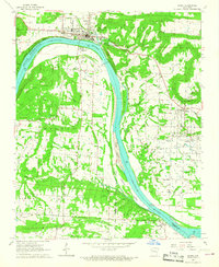
1966 Map of Ozark
USGS Topo · Published 1967About this map
The Arkansas River serves as the central artery of this mid-1960s landscape, just as significant infrastructure changes were taking hold. Near the town of Ozark, the construction of Lock and Dam No 12 and a nearby Powerplant signal a transition in the river's utility. Blue hatching across the terrain indicates areas destined to be submerged by the rising waters of the Ozark Reservoir, a transformation that would alter the shoreline near Webb City and surrounding lowlands.
Find a feature on this map
48 named features on this map. Tap any name to fly to it.
Don’t see what you’re looking for? This feature index may not catch every label — zoom into the map to look around manually.
Map Details
Editions of this 1966 Ozark Map
2 editions found
Other maps of this area

1879 · Cravens
USGS Topo · 1:62,500

1887 · Magazine Mountain #1
USGS Topo · 1:62,500

1887 · Magazine Mountain #2
USGS Topo · 1:62,500

1887 · Watalula
USGS Topo · 1:62,500

1887 · Magazine Mountain
USGS Topo · 1:62,500

1890 · Magazine Mountain
USGS Topo · 1:125,000

1906 · Batson
USGS Topo · 1:62,500

1939 · Watalula
USGS Topo · 1:62,500

1956 · Russellville
USGS Topo · 1:250,000

1961 · Coal Hill
USGS Topo · 1:24,000