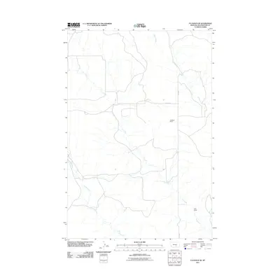
2011 Map of P K Ranch NE
USGS Topo · Published 2011About this map
Lookout Point rises above the drainage networks of Yellowstone County in this 2011 survey, overlooking a landscape defined by its seasonal waterways and rural transit routes. The geography is dominated by the winding course of Cow Gulch, which moves across the terrain alongside secondary tributaries like Railroad Creek and Hibbard Creek. These features illustrate the natural erosion patterns and hydraulic character of this part of Montana. Human presence is marked by the intersecting lines of Huffine Rd and Bundy Rd, providing a framework for the sparsely settled ranching territory. The map captures a specific moment in the early 21st century before modern development significantly altered the traditional footprints of these rural roadways and water courses.
Find a feature on this map
6 named features on this map. Tap any name to fly to it.
Don’t see what you’re looking for? This feature index may not catch every label — zoom into the map to look around manually.
Map Details
Editions of this 2011 P K Ranch NE Map
This is the sole edition of this map. No revisions or reprints were ever made.
Other maps of this area

1954 · Forsyth
USGS Topo · 1:250,000

1954 · Roundup
USGS Topo · 1:250,000

1957 · Forsyth
USGS Topo · 1:250,000

1958 · Roundup
USGS Topo · 1:250,000

1958 · Forsyth
USGS Topo · 1:250,000
1967 · Big Marys Island
USGS Topo · 1:24,000

1979 · Roundup
USGS Topo · 1:100,000

1979 · Hysham
USGS Topo · 1:100,000
1980 · P K Ranch NE
USGS Topo · 1:24,000
1980 · Bull Mountain NW
USGS Topo · 1:24,000