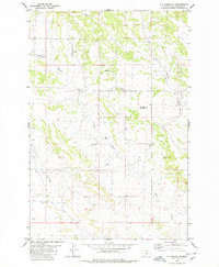
1980 Map of P K Ranch NE
USGS Topo · Published 1980About this map
The rugged breaklands of Cow Gulch and Railroad Creek define this rural landscape in Yellowstone County during the mid-1970s. This territory is characterized by a network of drainage systems that carve through the high plains, where isolated resources are marked by numerous Well sites scattered across the sections. The land use appears primarily centered on ranching and natural resource extraction, evidenced by the infrastructure needed to support life in this open country. A notable focal point for navigation and observation is Miller Lookout Point, which provides a high-ground perspective over the surrounding coulees. Near the eastern edge of the survey, a remote Landing Strip sits alongside Hibbard Creek, indicating the necessity of aerial access for managing these sprawling land holdings or monitoring local operations in a region where road travel remains limited to primitive tracks.
Find a feature on this map
8 named features on this map. Tap any name to fly to it.
Don’t see what you’re looking for? This feature index may not catch every label — zoom into the map to look around manually.
Map Details
Editions of this 1980 P K Ranch NE Map
This is the sole edition of this map. No revisions or reprints were ever made.
Other maps of this area

1954 · Forsyth
USGS Topo · 1:250,000

1954 · Roundup
USGS Topo · 1:250,000

1957 · Forsyth
USGS Topo · 1:250,000

1958 · Roundup
USGS Topo · 1:250,000

1958 · Forsyth
USGS Topo · 1:250,000
1967 · Big Marys Island
USGS Topo · 1:24,000

1979 · Roundup
USGS Topo · 1:100,000

1979 · Hysham
USGS Topo · 1:100,000
1980 · Bull Mountain NW
USGS Topo · 1:24,000
1980 · Steamboat Butte
USGS Topo · 1:24,000