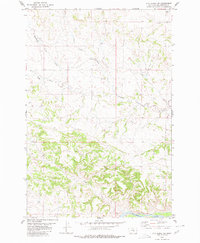
1980 Map of P K Ranch SW
USGS Topo · Published 1980About this map
The Yellowstone River anchors the southern boundary of this portion of Yellowstone County, where the river valley transitions into a series of drainages and upland ridges. The northern reaches are defined by the convergence of several waterways, including Pompeys Pillar Creek, Churn Dash Creek, and the West Fork creek system. This landscape reflects the rural Montana cattle and ranching country as it appeared in the late twentieth century, with topographic details highlighting the intricate network of coulees and breaks that shape the terrain. Scattered infrastructure such as a Well provides a glimpse into the essential water management required for land use in this semi-arid region. Further south, the meandering course of Rock Creek carves through the hills before approaching the broader floodplain of the river valley, illustrating the natural drainage patterns of the Yellowstone basin.
Find a feature on this map
9 named features on this map. Tap any name to fly to it.
Don’t see what you’re looking for? This feature index may not catch every label — zoom into the map to look around manually.
Map Details
Editions of this 1980 P K Ranch SW Map
This is the sole edition of this map. No revisions or reprints were ever made.
Other maps of this area

1893 · Huntley
USGS Topo · 1:125,000

1954 · Billings
USGS Topo · 1:250,000

1954 · Roundup
USGS Topo · 1:250,000

1956 · Huntley
USGS Topo · 1:24,000

1957 · Billings
USGS Topo · 1:250,000

1958 · Billings
USGS Topo · 1:250,000

1958 · Roundup
USGS Topo · 1:250,000

1967 · Nibbe
USGS Topo · 1:24,000

1967 · Worden
USGS Topo · 1:24,000

1979 · Roundup
USGS Topo · 1:100,000