
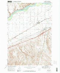
1967 Map of Worden
USGS Topo · Published 1971About this map
The Yellowstone River cuts across the northern edge of this Montana landscape, where the flat valley floor meets the rising terrain of Custer Coulee. In the late 1960s, the irrigation and transportation network defines the character of the region. The Main Canal runs parallel to the Burlington Northern railroad, serving the agricultural settlements of Worden and Ballantine. This corridor follows the historic route of the Lewis and Clark Trail, which stays north of the complex topography marked by Arrow Creek. Local industry and infrastructure are represented by several sites, including a Gravel Pit, a Borrow Pit, and a remote Landing Strip. The presence of numerous wells and the intricate network of the East Arrow Creek Road and West Arrow Creek Road reflect the managed ranching and farming operations that dominate the Yellowstone Valley during this era.
Find a feature on this map
19 named features on this map. Tap any name to fly to it.
Don’t see what you’re looking for? This feature index may not catch every label — zoom into the map to look around manually.
Map Details
Editions of this 1967 Worden Map
2 editions found
Other maps of this area

1893 · Huntley
USGS Topo · 1:125,000

1954 · Billings
USGS Topo · 1:250,000

1954 · Roundup
USGS Topo · 1:250,000

1956 · Huntley
USGS Topo · 1:24,000

1957 · Billings
USGS Topo · 1:250,000

1958 · Billings
USGS Topo · 1:250,000

1958 · Roundup
USGS Topo · 1:250,000

1967 · Nibbe
USGS Topo · 1:24,000

1967 · Cottonwood Creek
USGS Topo · 1:24,000
1969 · Indian Arrow
USGS Topo · 1:24,000