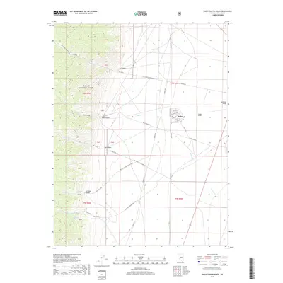
2018 Map of Pablo Canyon Ranch
USGS Topo · Published 2018About this map
The Toiyabe National Forest boundary marks the dramatic transition from the high, dissected ridges of the Toiyabe Range to the alluvial floors of the Big Smoky Valley. This 2018 survey documents a landscape defined by seasonal water and modern settlement, anchored by the community of Hadley. A series of deep drainages including Jett Canyon, Pablo Canyon, and Boyd Canyon emerge from the forest, feeding creeks that disappear into the valley floor. The map highlights the localized infrastructure of the region, from the Pablo Canyon Ranch to the Hadley Airport. Water sources like Antelope Spring and Boyd Canyon Spring indicate the critical points of hydration in this arid environment, while a network of forest development roads and local streets like Smokey Valley Blvd connect the isolated ranching and mining-related pockets to the larger valley corridor.
Find a feature on this map
51 named features on this map. Tap any name to fly to it.
Don’t see what you’re looking for? This feature index may not catch every label — zoom into the map to look around manually.
Map Details
Editions of this 2018 Pablo Canyon Ranch Map
This is the sole edition of this map. No revisions or reprints were ever made.
Other maps of this area

1907 · Tonopah
USGS Topo · 1:250,000

1908 · Tonopah
USGS Topo · 1:250,000

1956 · Tonopah
USGS Topo · 1:250,000

1959 · Tonopah
USGS Topo · 1:250,000

1962 · Tonopah
USGS Topo · 1:250,000

1971 · Carvers
USGS Topo · 1:24,000

1971 · Seyler Peak
USGS Topo · 1:24,000

1971 · Manhattan
USGS Topo · 1:24,000

1971 · Pablo Canyon Ranch
USGS Topo · 1:24,000
1971 · Carvers SE
USGS Topo · 1:24,000