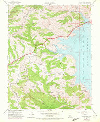
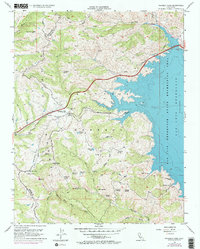
1955 Map of Pacheco Pass
USGS Topo · Published 1972About this map
Pacheco Pass serves as a critical mountain gateway through the Diablo Range, straddling the border between Santa Clara and Merced counties. This terrain is defined by the massive expansion of the San Luis Reservoir, whose blue waters and intricate shoreline are shown in detail alongside the San Luis State Recreation Area. The map reveals a complex hydrologic landscape of upland springs and small mountain lakes like Dinosaur Lake, Wolf Lake, and Nun Lake, which feed into steep drainages like Cottonwood Creek and San Luis Creek.
Find a feature on this map
42 named features on this map. Tap any name to fly to it.
Don’t see what you’re looking for? This feature index may not catch every label — zoom into the map to look around manually.
Map Details
Editions of this 1955 Pacheco Pass Map
5 editions found
Other maps of this area

1919 · Hollister
USGS Topo · 1:48,000

1920 · Pacheco Pass
USGS Topo · 1:62,500

1921 · Gilroy Hot Springs
USGS Topo · 1:62,500

1921 · Hollister
USGS Topo · 1:62,500

1922 · Quien Sabe
USGS Topo · 1:62,500

1922 · San Luis Creek
USGS Topo · 1:31,680

1922 · Howard Ranch
USGS Topo · 1:31,680

1923 · Hollister
USGS Topo · 1:62,500

1939 · Gilroy Hot Springs
USGS Topo · 1:62,500

1940 · Gilroy Hot Springs
USGS Topo · 1:62,500