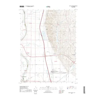
2018 Map of Pacific Junction
USGS Topo · Published 2018About this map
The Missouri River defines the western edge of this landscape, carving a wide alluvial plain that meets the rugged Loess Hills of Iowa. The rail-and-river hub of Pacific Junction sits near the base of these bluffs, anchored by the BNSF Railway tracks that cut through the flat bottomlands. To the north, the small settlement of Folsom is situated between the hills and the wetlands of Folsom Lake. This area is particularly dense with historic burial grounds, from the Pacific City Cem to smaller hilltop sites like Gowen Cem and Wall Cem. The topography transitions sharply from the straightened channels of Eaton Ditch and Pony Cr Ditch on the valley floor to the intricate ravines of Wall Hollow and Indian Hollow. On the Nebraska side, Plattsmouth appears at the southwestern corner, connected by the river crossing to a complex network of drainage ditches and oxbow remnants like Schilling Lake.
Find a feature on this map
81 named features on this map. Tap any name to fly to it.
Don’t see what you’re looking for? This feature index may not catch every label — zoom into the map to look around manually.
Map Details
Editions of this 2018 Pacific Junction Map
This is the sole edition of this map. No revisions or reprints were ever made.
Other maps of this area

1935 · Nehawka
USGS Topo · 1:48,000

1940 · Nehawka
USGS Topo · 1:62,500

1954 · Omaha
USGS Topo · 1:250,000

1955 · Nebraska City
USGS Topo · 1:250,000

1956 · Glenwood
USGS Topo · 1:24,000

1956 · Mineola
USGS Topo · 1:24,000

1956 · Murray
USGS Topo · 1:24,000

1956 · Rock Bluff
USGS Topo · 1:24,000

1956 · Plattsmouth
USGS Topo · 1:24,000

1956 · Pacific Junction
USGS Topo · 1:24,000