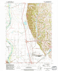
1993 Map of Pacific Junction
USGS Topo · Published 1995About this map
The Missouri River forms the western boundary of this landscape, separating the bottomlands of Sarpy and Cass counties from the bluffs of Iowa. This 1993 field-checked survey reveals a complex network of flood control measures, including an extensive Road on Levee system and St Marys Ditch. The rail infrastructure of the Burlington Northern intersects at the town of Pacific Junction, a historically significant rail hub that defines the local geography. East of the river flats, the terrain rises into named ravines like Wall Hollow and Indian Hollow. Researchers will find several family-named burial sites along these ridges, such as Wall Cem and Gowen Cem, alongside smaller water bodies like Folsom Lake and Pony Creek Lake. The map also captures the Schilling State Wildlife Area on the river's bend near Plattsmouth.
Find a feature on this map
32 named features on this map. Tap any name to fly to it.
Don’t see what you’re looking for? This feature index may not catch every label — zoom into the map to look around manually.
Map Details
Editions of this 1993 Pacific Junction Map
This is the sole edition of this map. No revisions or reprints were ever made.
Other maps of this area

1935 · Nehawka
USGS Topo · 1:48,000

1940 · Nehawka
USGS Topo · 1:62,500

1954 · Omaha
USGS Topo · 1:250,000

1955 · Nebraska City
USGS Topo · 1:250,000

1956 · Glenwood
USGS Topo · 1:24,000

1956 · Mineola
USGS Topo · 1:24,000

1956 · Murray
USGS Topo · 1:24,000

1956 · Rock Bluff
USGS Topo · 1:24,000

1956 · Plattsmouth
USGS Topo · 1:24,000

1956 · Pacific Junction
USGS Topo · 1:24,000