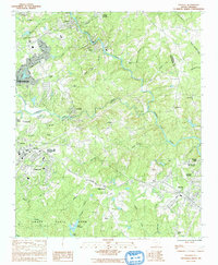
1983 Map of Pacolet
USGS Topo · Published 1992About this map
The Pacolet River carves a deep, winding path through the Piedmont landscape of Spartanburg County, serving as the historical backbone for the industrial and residential clusters shown here in the early 1980s. Textile heritage is evident in the layout of settlements like Pacolet Mills, Clifton, and Glendale, where housing and infrastructure closely follow the river's course. To the southwest, the extensive grounds of Croft State Park and Camp Croft occupy a significant portion of the map, revealing the transformation of former military training lands into a large public recreational space. The mapping records a transition from these concentrated mill villages to the outward expansion of eastern Spartanburg. Numerous rural landmarks, including the Bagwell Cem, Bethesda Ch, and Hammett Grove Ch, provide essential touchstones for genealogists tracing family roots within the smaller communities of Central Pacolet and Maryville.
Find a feature on this map
48 named features on this map. Tap any name to fly to it.
Don’t see what you’re looking for? This feature index may not catch every label — zoom into the map to look around manually.
Map Details
Editions of this 1983 Pacolet Map
2 editions found
Other maps of this area

1909 · Gaffney
USGS Topo · 1:62,500

1941 · Spartanburg
USGS Topo · 1:250,000

1947 · Spartanburg
USGS Topo · 1:62,500

1949 · Spartanburg
USGS Topo · 1:24,000

1949 · Spartanburg
USGS Topo · 1:62,500

1953 · Spartanburg
USGS Topo · 1:250,000

1953 · Charlotte
USGS Topo · 1:250,000

1954 · Charlotte
USGS Topo · 1:250,000

1959 · Cowpens
USGS Topo · 1:62,500

1960 · Charlotte
USGS Topo · 1:250,000