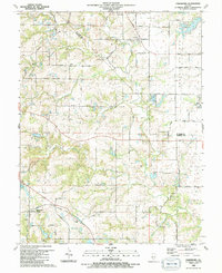
1990 Map of Paderborn
USGS Topo · Published 1991About this map
The crossroads community of Paderborn and the surrounding agricultural lands of Long Prairie define this portion of southwestern Illinois at the transition from the 1980s. The landscape is deeply etched by the drainage of Prairie du Long Creek and its many tributaries, including Gerhardt Creek and Walters Creek. This survey captures a network of rural life anchored by historic religious and social centers, such as St Michaels Ch and the nearby Grange Hall.
Find a feature on this map
45 named features on this map. Tap any name to fly to it.
Don’t see what you’re looking for? This feature index may not catch every label — zoom into the map to look around manually.
Map Details
Editions of this 1990 Paderborn Map
This is the sole edition of this map. No revisions or reprints were ever made.
Other maps of this area

1910 · Waterloo
USGS Topo · 1:62,500

1912 · New Athens
USGS Topo · 1:62,500

1912 · Baldwin
USGS Topo · 1:62,500

1913 · Waterloo
USGS Topo · 1:62,500

1914 · Baldwin
USGS Topo · 1:62,500

1915 · Renault
USGS Topo · 1:62,500

1940 · Renault
USGS Topo · 1:62,500

1942 · Baldwin
USGS Topo · 1:62,500

1949 · Saint Louis
USGS Topo · 1:250,000
1951 · Columbia
USGS Topo · 1:24,000