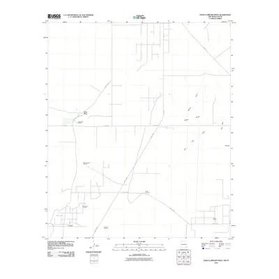
2010 Map of Paduca Breaks West
USGS Topo · Published 2010About this map
Ross Place and the Battle-axe Ranch anchor this landscape in the southeastern corner of New Mexico at the start of the twenty-first century. The map reveals an arid terrain defined by the Paduca Breaks and the Red Hills, where water management is critical to the local economy. A network of isolated outposts and livestock infrastructure is evident through features like Sweetwater Windmill, Battle-axe West Windmill, and Hackberry Windmill. This area, where Eddy County meets the Texas state line, is heavily shaped by energy extraction. The extensive footprint of the North Mason Oil Field and the El Mar Oil Field is documented alongside the industrial arteries of Pipeline Rd and County Hwy-1, which facilitate movement through the scrub and draws.
Find a feature on this map
18 named features on this map. Tap any name to fly to it.
Don’t see what you’re looking for? This feature index may not catch every label — zoom into the map to look around manually.
Map Details
Editions of this 2010 Paduca Breaks West Map
This is the sole edition of this map. No revisions or reprints were ever made.
Other maps of this area

1931 · Orla
USGS Topo · 1:62,500

1954 · Hobbs
USGS Topo · 1:250,000

1954 · Pecos
USGS Topo · 1:250,000

1957 · Pecos
USGS Topo · 1:250,000

1958 · Hobbs
USGS Topo · 1:250,000

1968 · Orla NE
USGS Topo · 1:24,000

1968 · Phantom Banks
USGS Topo · 1:24,000
1968 · Big Sinks
USGS Topo · 1:24,000

1969 · Kyle Ranch
USGS Topo · 1:24,000

1969 · Rudd Draw NE
USGS Topo · 1:24,000