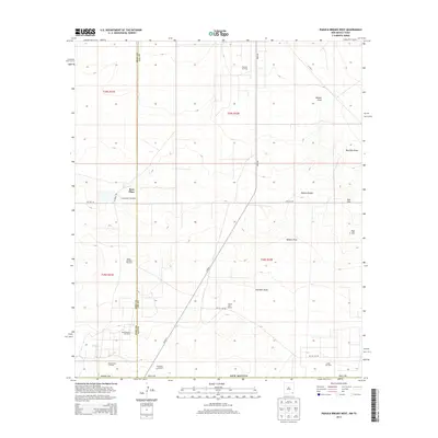
2013 Map of Paduca Breaks West
USGS Topo · Published 2013About this map
Paduca Breaks and the winding course of Bobcat Draw define the topography of this corner of the Permian Basin where the border of Eddy County meets Lea County. In 2013, the landscape reflects a working territory shaped by the petroleum industry and cattle ranching. Remote outposts like Battle-axe Ranch and Ross Place sit alongside localized infrastructure such as Sweetwater Windmill and Hackberry Windmill, which provide critical water in this arid stretch of New Mexico. The map clearly delineates the extent of energy development in the area, marking the boundaries of the Paduca Oil Field, North Mason Oil Field, and El Mar Oil Field. A network of unpaved paths, including CO Hwy-1 and Battle Axe Rd, connects these isolated industrial sites and ranching headquarters across the rolling desert floor.
Find a feature on this map
25 named features on this map. Tap any name to fly to it.
Don’t see what you’re looking for? This feature index may not catch every label — zoom into the map to look around manually.
Map Details
Editions of this 2013 Paduca Breaks West Map
This is the sole edition of this map. No revisions or reprints were ever made.
Other maps of this area

1931 · Orla
USGS Topo · 1:62,500

1954 · Hobbs
USGS Topo · 1:250,000

1954 · Pecos
USGS Topo · 1:250,000

1957 · Pecos
USGS Topo · 1:250,000

1958 · Hobbs
USGS Topo · 1:250,000

1968 · Orla NE
USGS Topo · 1:24,000

1968 · Phantom Banks
USGS Topo · 1:24,000
1968 · Big Sinks
USGS Topo · 1:24,000

1969 · Kyle Ranch
USGS Topo · 1:24,000

1969 · Rudd Draw NE
USGS Topo · 1:24,000