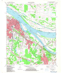
1982 Map of Paducah East
USGS Topo · Published 1983About this map
The confluence of the Ohio River and the Tennessee River serves as the focal point for this 1980s portrait of Paducah. This river-driven economy is evident in the extensive rail infrastructure of the Illinois Central and the presence of the North Yard. While the urban core contains the Courthouse and Barkley Museum, the surrounding areas like Tyler, Woodlawn, and Reidland show the post-war suburban growth typical of Western Kentucky. Genealogists will find a high density of family and community landmarks, including the large Oak Grove Cem and Maplelawn Cem, along with numerous rural houses of worship such as Highland Ch and Hamilton Chapel. The landscape is defined by the alluvial geography of Black Gray Ridge and the complex waterways of Clarks River and its various branches.
Find a feature on this map
85 named features on this map. Tap any name to fly to it.
Don’t see what you’re looking for? This feature index may not catch every label — zoom into the map to look around manually.
Map Details
Editions of this 1982 Paducah East Map
This is the sole edition of this map. No revisions or reprints were ever made.
Other maps of this area

1926 · Paducah
USGS Topo · 1:62,500

1929 · Smithland
USGS Topo · 1:62,500

1929 · Paducah
USGS Topo · 1:62,500

1936 · Melber
USGS Topo · 1:24,000

1936 · Paducah
USGS Topo · 1:24,000

1936 · Elva
USGS Topo · 1:24,000

1936 · Smithland
USGS Topo · 1:48,000

1936 · Symsonia
USGS Topo · 1:24,000

1936 · Benton
USGS Topo · 1:48,000

1936 · Little Cypress
USGS Topo · 1:24,000