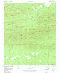
1981 Map of Page
USGS Topo · Published 1981About this map
Quachita National Forest dominates this landscape in Le Flore County, where the steep ridges of Rich Mountain and Black Fork Mountain define the topography. In the central valley, the small settlement of Page serves as a focal point, situated along the Kansas City Southern tracks. This community is home to the Page Ch and Page Cem, while the nearby McClure Cem provides additional genealogical value for those researching local families.
Find a feature on this map
39 named features on this map. Tap any name to fly to it.
Don’t see what you’re looking for? This feature index may not catch every label — zoom into the map to look around manually.
Map Details
Editions of this 1981 Page Map
2 editions found
Other maps of this area

1887 · Poteau Mountain #2
USGS Topo · 1:62,500

1890 · Poteau Mountain
USGS Topo · 1:125,000

1899 · Poteau Mountain
USGS Topo · 1:125,000

1900 · Winding Stair
USGS Topo · 1:125,000

1909 · Winding Stair
USGS Topo · 1:125,000

1950 · Mcalester
USGS Topo · 1:250,000
1958 · Loving
USGS Topo · 1:24,000
1958 · Bates
USGS Topo · 1:62,500

1958 · Potter
USGS Topo · 1:62,500

1958 · Zafra
USGS Topo · 1:24,000