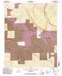
1995 Map of Page
USGS Topo · Published 1997About this map
Cibola National Forest dominates this high-altitude landscape, where the Continental Divide winds through the eastern ridges of the Zuni Mountains. The terrain is defined by dramatic elevations and seasonal water sources, featuring prominent landforms like McKenzie Ridge and Oso Ridge. This 1995 revision reveals a rugged settlement pattern focused on family-named places and ranching outposts such as Silva Ranch and Radosevich Ranch. Small clusters of human activity, such as Page and Bloomfield Flat, are scattered among high canyons and alluvial flats. The map documents an extensive network of livestock infrastructure, including Basgal Tank, McKenzie Tank, and numerous other tanks that supported ranching operations across the McKinley and Cibola county line. Many of these named locations, like Basgal Place and Navarre Place, provide specific geographic markers for family researchers tracking the mid-to-late 20th-century history of the region.
Find a feature on this map
41 named features on this map. Tap any name to fly to it.
Don’t see what you’re looking for? This feature index may not catch every label — zoom into the map to look around manually.
Map Details
Editions of this 1995 Page Map
This is the sole edition of this map. No revisions or reprints were ever made.
Other maps of this area

1886 · Wingate
USGS Topo · 1:250,000

1892 · Wingate
USGS Topo · 1:250,000

1954 · Gallup
USGS Topo · 1:250,000

1958 · Gallup
USGS Topo · 1:250,000

1959 · Gallup
USGS Topo · 1:250,000

1961 · Cottonwood Canyon
USGS Topo · 1:24,000

1962 · Gallup
USGS Topo · 1:250,000

1962 · Ciniza
USGS Topo · 1:24,000

1962 · Continental Divide
USGS Topo · 1:24,000

1962 · Cottonwood Canyon
USGS Topo · 1:24,000