
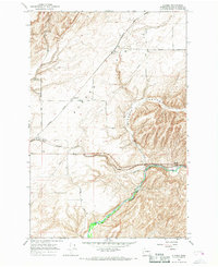
1966 Map of Page
USGS Topo · Published 1967About this map
Lake Sacajawea and the Snake River dominate the northern landscape of this region, serving as the boundary between Franklin and Walla Walla counties. The mid-1960s terrain is defined by the agricultural expanse of Eureka Flat and the intricate transport network required to move grain through the Columbia Basin. Small railway outposts like Hatch, Adkins, and Page are situated along the Union Pacific and Northern Pacific lines, underscoring the era's reliance on rail for commerce. Near the river, the presence of Sand Dunes and multiple Gravel Pits reflects the area's geomorphology, while the Grain Elevator at Hatch and a nearby Landing Strip illustrate the specialized infrastructure of a mid-century Pacific Northwest farming community. This survey also records the path of several named local routes including Van Hollebeke Rd and Page Road.
Find a feature on this map
28 named features on this map. Tap any name to fly to it.
Don’t see what you’re looking for? This feature index may not catch every label — zoom into the map to look around manually.
Map Details
Editions of this 1966 Page Map
This is the sole edition of this map. No revisions or reprints were ever made.
Other maps of this area

1915 · Wallulah
USGS Topo · 1:96,000

1918 · Wallula
USGS Topo · 1:125,000

1953 · Walla Walla
USGS Topo · 1:250,000

1958 · Walla Walla
USGS Topo · 1:250,000

1964 · Levey SE
USGS Topo · 1:24,000

1964 · Slater
USGS Topo · 1:24,000

1964 · Levey NE
USGS Topo · 1:24,000

1966 · Snake River
USGS Topo · 1:24,000

1966 · Rulo
USGS Topo · 1:24,000
1966 · Eureka
USGS Topo · 1:24,000