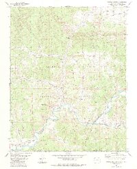
1984 Map of Pagosa Junction
USGS Topo · Published 1984About this map
Pagosa Junction (Gato) and Juanita anchor this high-desert landscape along the Colorado and New Mexico border, where the San Juan River winds through deep canyons and broad valleys. This 1984 edition illustrates the enduring geography of the Southern Ute Indian Reservation, which occupies the northern half of the territory. The topography is defined by intricate drainage systems like Cañada de la Nutrita and Frijoles Canyon, while human activity is evidenced by a Gas Well and a small Prospect. Transportation history is clearly visible through the Old Railroad Grade that parallels the river, marking a former corridor of transit through this isolated region. Local life is further represented by a small Cem near the river junction and a Ford providing a crossing point at the state line.
Find a feature on this map
29 named features on this map. Tap any name to fly to it.
Don’t see what you’re looking for? This feature index may not catch every label — zoom into the map to look around manually.
Map Details
Editions of this 1984 Pagosa Junction Map
2 editions found
Other maps of this area

1889 · Largo
USGS Topo · 1:250,000

1895 · Largo
USGS Topo · 1:250,000

1924 · Pagosa Springs
USGS Topo · 1:125,000

1927 · Pagosa Springs
USGS Topo · 1:125,000

1945 · Durango
USGS Topo · 1:250,000

1953 · Durango
USGS Topo · 1:250,000

1954 · Durango
USGS Topo · 1:250,000

1954 · Carracas
USGS Topo · 1:24,000

1954 · Aztec
USGS Topo · 1:250,000

1957 · Pagosa Junction
USGS Topo · 1:62,500