
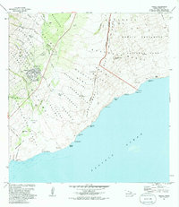
1981 Map of Pahala
USGS Topo · Published 1981About this map
Pahala serves as the central hub of this coastal landscape on the southern flank of Mauna Loa, appearing here in the early 1980s. The map illustrates a transition from the agricultural and residential layout of the town to the volcanic wilderness of Hawaii Volcanoes National Park. Significant geologic activity is evident through the presence of the Great Crack and the Keaiwa Rift Zone, which underscore the dynamic nature of the Kau District.
Find a feature on this map
57 named features on this map. Tap any name to fly to it.
Don’t see what you’re looking for? This feature index may not catch every label — zoom into the map to look around manually.
Map Details
Editions of this 1981 Pahala Map
2 editions found
Other maps of this area

1921 · Kilauea
USGS Topo · 1:62,500

1923 · Pahala
USGS Topo · 1:62,500

1924 · Kilauea
USGS Topo · 1:62,500

1924 · Honuapo
USGS Topo · 1:62,500

1928 · Mauna Loa
USGS Topo · 1:62,500

1954 · Hawaii South
USGS Topo · 1:250,000

1959 · Hawaii South
USGS Topo · 1:250,000

1961 · Hawaii South
USGS Topo · 1:250,000

1962 · Hawaii South
USGS Topo · 1:250,000
1962 · Naalehu
USGS Topo · 1:24,000