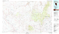
1979 Map of Pahute Mesa
USGS Topo · Published 1996About this map
Nellis Air Force Range and the Nevada Test Site dominate this landscape, revealing the Cold War era's heavy military and scientific footprint across the high desert. The map is meticulously partitioned into designated areas, including Area 20 and Area 12, and identifies specific facilities like the Radioactive Waste Dump near Yucca Flat. This restricted zone contrasts sharply with the traces of earlier pioneer industry located on the western fringes, where the Pioneer Mine and Clarkdale Mine sit near the edge of Sarcobatus Flat.
Find a feature on this map
92 named features on this map. Tap any name to fly to it.
Don’t see what you’re looking for? This feature index may not catch every label — zoom into the map to look around manually.
Map Details
Editions of this 1979 Pahute Mesa Map
2 editions found
Other maps of this area

1907 · Las Vegas
USGS Topo · 1:250,000

1908 · Kawich
USGS Topo · 1:250,000

1908 · Lida
USGS Topo · 1:250,000

1908 · Furnace Creek
USGS Topo · 1:250,000

1908 · Las Vegas
USGS Topo · 1:250,000

1908 · Ballarat
USGS Topo · 1:250,000

1910 · Furnace Creek
USGS Topo · 1:250,000

1913 · Lida
USGS Topo · 1:250,000

1913 · Ballarat
USGS Topo · 1:250,000

1942 · Emigrant Valley
USGS Topo · 1:125,000