
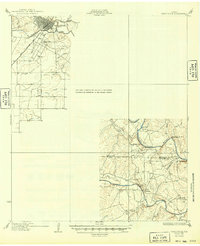
1932 Map of Paint Rock
USGS Topo · Published 1932About this map
Ballinger sits at the northern edge of this West Texas survey, where the Gulf Colorado and Santa Fe RR crosses the Colorado River. The landscape is defined by the confluence of major waterways and the rolling prairie of the Runnels and Concho county line. Local education at this time was decentralized, evidenced by several rural schoolhouses serving distant ranches, including Dry Ridge Sch, Mapes Sch, and Currie Sch.
Find a feature on this map
23 named features on this map. Tap any name to fly to it.
Don’t see what you’re looking for? This feature index may not catch every label — zoom into the map to look around manually.
Map Details
Editions of this 1932 Paint Rock Map
2 editions found
Other maps of this area

1891 · Hayrick
USGS Topo · 1:125,000

1892 · San Angelo
USGS Topo · 1:125,000

1892 · Eden
USGS Topo · 1:125,000

1892 · Ballinger
USGS Topo · 1:125,000

1894 · Hayrick
USGS Topo · 1:125,000

1896 · Eden
USGS Topo · 1:125,000

1921 · Hatchel
USGS Topo · 1:31,680

1921 · Lowake
USGS Topo · 1:31,680

1921 · Quarry Creek
USGS Topo · 1:31,680

1921 · Spur Creek
USGS Topo · 1:31,680