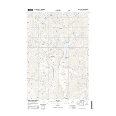
2014 Map of Painted Rocks Lake
USGS Topo · Published 2014About this map
Painted Rocks Lake sits at the heart of this Bitterroot mountain landscape, where the W Fork Bitterroot River and West Fork Bitterroot River converge within the Bitterroot National Forest. The geography is defined by a dense network of drainages and high points, including Lookout Mtn and West Mtn, separated by significant saddles such as Mud Creek Saddle and Tough Creek Saddle. The area's character is shaped by its forest service infrastructure and isolated naming conventions, featuring narrow access ways like Hawks Nest Ln and recreational paths such as the Mountain Lion Trl. This documentation of the area shows the intersection of natural water systems, from Hot Springs to Little Blue Joint Cr, with the administrative boundaries of the national forest. The layout of roads like Blue Joint Rd and State Creek Rd reflects the topographical constraints of a region dominated by high ridges like Coal Ridge.
Find a feature on this map
39 named features on this map. Tap any name to fly to it.
Don’t see what you’re looking for? This feature index may not catch every label — zoom into the map to look around manually.
Map Details
Editions of this 2014 Painted Rocks Lake Map
This is the sole edition of this map. No revisions or reprints were ever made.
Other maps of this area

1956 · Elk City
USGS Topo · 1:250,000

1960 · Elk City
USGS Topo · 1:250,000

1960 · Painted Rocks Lake
USGS Topo · 1:62,500

1960 · Piquett Mountain
USGS Topo · 1:62,500

1964 · Boulder Peak
USGS Topo · 1:24,000
1964 · Mount Jerusalem
USGS Topo · 1:24,000

1964 · Piquett Creek
USGS Topo · 1:24,000
1991 · Piquett Mountain
USGS Topo · 1:24,000

1991 · Horse Creek Pass
USGS Topo · 1:24,000
1991 · Henderson Ridge
USGS Topo · 1:24,000