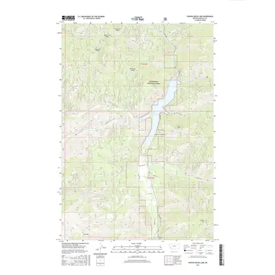
2017 Map of Painted Rocks Lake
USGS Topo · Published 2017About this map
Painted Rocks Lake sits at the heart of this high-elevation landscape within the Bitterroot National Forest. Fed by the W Fork Bitterroot River and various mountain drainages like Blue Joint Cr and Coal Cr, the reservoir serves as a central landmark for the surrounding terrain. The geography is defined by prominent peaks and ridges, including West Mtn and Lookout Mtn, interspersed with named saddles such as Mud Creek Saddle and Took Ridge Saddle. A single Hot Springs site is noted west of the lake near Little Blue Joint Cr. The network of forest roads, including Blue Joint Rd and Overwhich Rd, provides access through the steep gulches and creek beds that characterize this part of Ravalli County.
Find a feature on this map
41 named features on this map. Tap any name to fly to it.
Don’t see what you’re looking for? This feature index may not catch every label — zoom into the map to look around manually.
Map Details
Editions of this 2017 Painted Rocks Lake Map
This is the sole edition of this map. No revisions or reprints were ever made.
Other maps of this area

1956 · Elk City
USGS Topo · 1:250,000

1960 · Elk City
USGS Topo · 1:250,000

1960 · Painted Rocks Lake
USGS Topo · 1:62,500

1960 · Piquett Mountain
USGS Topo · 1:62,500

1964 · Boulder Peak
USGS Topo · 1:24,000
1964 · Mount Jerusalem
USGS Topo · 1:24,000

1964 · Piquett Creek
USGS Topo · 1:24,000
1991 · Piquett Mountain
USGS Topo · 1:24,000

1991 · Horse Creek Pass
USGS Topo · 1:24,000
1991 · Henderson Ridge
USGS Topo · 1:24,000