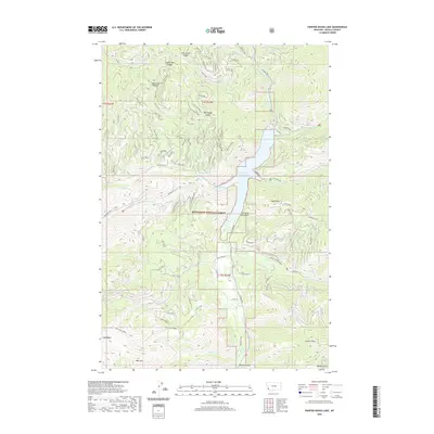
2020 Map of Painted Rocks Lake
USGS Topo · Published 2020About this map
Bitterroot National Forest dominates this mountain landscape, defined by the sharp vertical relief of the Bitterroot Range. The central focus is Painted Rocks Lake, a reservoir created on the West Fork Bitterroot River, where Blue Joint Bay and the mouth of Slate Creek shape the shoreline. High ridgelines and summits such as Jew Mountain, West Mountain, and Lookout Mountain provide a glimpse into the topographical barriers that historical travelers and foresters navigated. Access into the drainage is marked by numerous saddles, including Took Ridge Saddle and Mud Creek Saddle. The mapping of named drainages like Fourth of July Gulch and Little Blue Joint Creek illustrates the intricate watershed system feeding the West Fork. A network of forest roads, such as Overwhich Road and Coal Creek Road, snakes through the valleys and over ridges like Razorback Ridge, tracing the routes used for contemporary timber management and recreation in this remote Montana wilderness.
Find a feature on this map
51 named features on this map. Tap any name to fly to it.
Don’t see what you’re looking for? This feature index may not catch every label — zoom into the map to look around manually.
Map Details
Editions of this 2020 Painted Rocks Lake Map
This is the sole edition of this map. No revisions or reprints were ever made.
Other maps of this area

1956 · Elk City
USGS Topo · 1:250,000

1960 · Elk City
USGS Topo · 1:250,000

1960 · Painted Rocks Lake
USGS Topo · 1:62,500

1960 · Piquett Mountain
USGS Topo · 1:62,500

1964 · Boulder Peak
USGS Topo · 1:24,000
1964 · Mount Jerusalem
USGS Topo · 1:24,000

1964 · Piquett Creek
USGS Topo · 1:24,000
1991 · Piquett Mountain
USGS Topo · 1:24,000

1991 · Horse Creek Pass
USGS Topo · 1:24,000
1991 · Henderson Ridge
USGS Topo · 1:24,000