2024 Map of Paisley
USGS Topo · Published 2024About this map
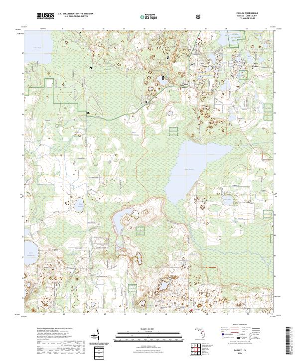
Paisley and the small settlement of Johnsons Corner sit at the intersection of rural life and protected wilderness in Lake County. This landscape is defined by the southeastern reaches of the Ocala National Forest, where dense forest gives way to an intricate system of water bodies. The Wekiva Wild and Scenic River flows through the southern portion of the quadrangle, serving as a primary drainage for the surrounding wetlands like Black Water Swamp. High ground is found along Blue Lakes Ridge, a geological feature that separates numerous small kettle lakes such as Lake Lulu and Mirror Lake. For local historians, the Ponceannah Cem remains a grounded point of reference north of the larger waters of Lake Norris, while the Florida National Scenic Trl highlights the area's modern role as a recreational hub for backcountry exploration.
Find a feature on this map
127 named features on this map. Tap any name to fly to it.
Don’t see what you’re looking for? This feature index may not catch every label — zoom into the map to look around manually.
Map Details
Editions of this 2024 Paisley Map
This is the sole edition of this map. No revisions or reprints were ever made.
Other maps of this area

1954 · Daytona Beach
USGS Topo · 1:250,000

1955 · Orlando
USGS Topo · 1:250,000

1957 · Orlando
USGS Topo · 1:250,000

1958 · Orlando
USGS Topo · 1:250,000

1958 · Daytona Beach
USGS Topo · 1:250,000

1960 · Sorrento
USGS Topo · 1:24,000

1962 · Orlando
USGS Topo · 1:250,000

1962 · Pine Lakes
USGS Topo · 1:24,000

1962 · Lake Woodruff
USGS Topo · 1:24,000

1964 · Daytona Beach
USGS Topo · 1:250,000