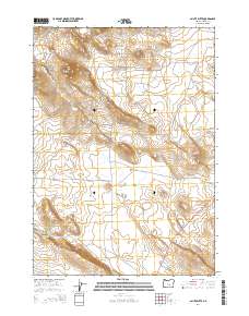
2014 Map of Paiute Butte
USGS Topo · Published 2014About this map
Paiute Butte rises as the primary landmark in this high-desert portion of Harney County, overlooking a complex of ephemeral basins and scattered water sources. This 2014 survey captures a landscape defined by its hydrography, where seasonal features like China Lake, Papoose Lake, and Evening Lake dot the terrain alongside more reliable points such as the Yellowstone Waterhole. The map illustrates a remote infrastructure dependent on a sparse network of roads, including Placidea Butte Rd and Big Stick Rd, which connect these interior basins to the primary artery of Us-395. In the southwest corner, the Lone Tree Reservoir and Big Stick Cr represent vital managed water resources in an otherwise arid environment, providing clear evidence of how topographic depressions are utilized for water catchment in this expansive Oregon range.
Find a feature on this map
15 named features on this map. Tap any name to fly to it.
Don’t see what you’re looking for? This feature index may not catch every label — zoom into the map to look around manually.
Map Details
Editions of this 2014 Paiute Butte Map
This is the sole edition of this map. No revisions or reprints were ever made.
Other maps of this area

1955 · Burns
USGS Topo · 1:250,000

1958 · Burns
USGS Topo · 1:250,000

1959 · Burns
USGS Topo · 1:250,000

1980 · Capehart Lake
USGS Topo · 1:24,000

1980 · Squaw Butte
USGS Topo · 1:24,000

1980 · Alec Butte
USGS Topo · 1:24,000

1980 · Hay Lake
USGS Topo · 1:24,000

1980 · Wagontire Mtn East
USGS Topo · 1:24,000

1980 · Lake on The Trail
USGS Topo · 1:24,000
1981 · Potato Hills
USGS Topo · 1:24,000