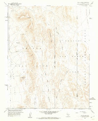
1961 Map of Paiute Ridge
USGS Topo · Published 1962About this map
Nevada Test Site operations define this Cold War landscape, where mapping in 1961 reveals the early infrastructure of atomic research and military training. This quadrangle covers the intersection of the test site with the Nellis Air Force Range and the Desert Game Range. The terrain is marked by distinctive topographic features like Slanted Buttes and Paiute Ridge, while specialized facility labels provide significant historical context. Notable sites include a Radioactive Waste Dump and Camera Station Butte Alpha, as well as the ominously named Plutonium Valley. A network of jeep trails winds through West Fork Scarp Canyon and East Fork Scarp Canyon, connecting various restricted areas such as Area 9 and Area 7. This document captures the remote desert at a time when its utility was being fundamentally reshaped by nuclear-age requirements.
Find a feature on this map
24 named features on this map. Tap any name to fly to it.
Don’t see what you’re looking for? This feature index may not catch every label — zoom into the map to look around manually.
Map Details
Editions of this 1961 Paiute Ridge Map
3 editions found
Other maps of this area

1907 · Las Vegas
USGS Topo · 1:250,000

1908 · Kawich
USGS Topo · 1:250,000

1908 · Furnace Creek
USGS Topo · 1:250,000

1908 · Las Vegas
USGS Topo · 1:250,000

1910 · Furnace Creek
USGS Topo · 1:250,000

1942 · Emigrant Valley
USGS Topo · 1:125,000

1942 · Indian Spring
USGS Topo · 1:125,000

1942 · Wheelbarrow Peak
USGS Topo · 1:125,000

1942 · Skull Mountain
USGS Topo · 1:125,000

1948 · Death Valley
USGS Topo · 1:250,000