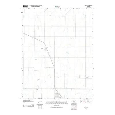
2009 Map of Palco
USGS Topo · Published 2009About this map
The town of Palco and the nearby village of Damar anchor this section of Rooks County, illustrating the agricultural and extractive character of the Kansas plains. To the north, the South Fork Solomon River meanders across the terrain, joined by smaller watercourses like Spring Creek and Lost Creek. The landscape is heavily influenced by the petroleum industry, with significant activity visible at the Morel Oil Field, the Gra-Rook Oil Field, and the Gra-Rook North Oil Field. For genealogists, the map identifies several key burial sites, including Saint Joseph Cemetery near Damar, as well as Palco Cemetery and Green Mound Cemetery. The strictly gridded road network, featuring routes such as O RD, S RD, and V RD, reflects the systematic land division that defines the region’s development and rural transport patterns.
Find a feature on this map
26 named features on this map. Tap any name to fly to it.
Don’t see what you’re looking for? This feature index may not catch every label — zoom into the map to look around manually.
Map Details
Editions of this 2009 Palco Map
This is the sole edition of this map. No revisions or reprints were ever made.
Other maps of this area

1893 · Hill
USGS Topo · 1:125,000

1896 · Plainville
USGS Topo · 1:125,000

1952 · Webster Dam
USGS Topo · 1:24,000

1955 · Beloit
USGS Topo · 1:250,000

1959 · Beloit
USGS Topo · 1:250,000

1969 · Nicodemus
USGS Topo · 1:24,000

1969 · Palco
USGS Topo · 1:24,000

1969 · Stockton SW
USGS Topo · 1:24,000
1978 · Zurich
USGS Topo · 1:24,000

1979 · Bogue
USGS Topo · 1:24,000