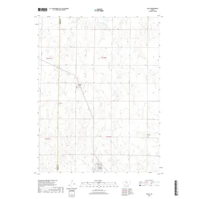
2018 Map of Palco
USGS Topo · Published 2018About this map
Palco and Damar serve as the primary hubs of this Rooks County landscape, positioned along a diagonal transportation corridor that cuts through the established section lines. The village of Damar is tightly clustered around Oak St, while Palco shows a more structured grid including Main St and Gum Ave. This 2018 survey reveals a rural infrastructure defined by an orderly network of numbered and lettered roads, such as O Rd and 390 Th Ave, which provide access to the surrounding agricultural plains. Water sources like the S Fork Solomon River in the north and the meandering Spring Cr create natural drainage patterns across the terrain. For those researching local heritage, the map identifies several burial sites including Saint Joseph Cem near the Graham County line, Palco Cem, and the remote Green Mound Cem located near Lost Cr.
Find a feature on this map
37 named features on this map. Tap any name to fly to it.
Don’t see what you’re looking for? This feature index may not catch every label — zoom into the map to look around manually.
Map Details
Editions of this 2018 Palco Map
This is the sole edition of this map. No revisions or reprints were ever made.
Other maps of this area

1893 · Hill
USGS Topo · 1:125,000

1896 · Plainville
USGS Topo · 1:125,000

1952 · Webster Dam
USGS Topo · 1:24,000

1955 · Beloit
USGS Topo · 1:250,000

1959 · Beloit
USGS Topo · 1:250,000

1969 · Nicodemus
USGS Topo · 1:24,000

1969 · Palco
USGS Topo · 1:24,000

1969 · Stockton SW
USGS Topo · 1:24,000
1978 · Zurich
USGS Topo · 1:24,000

1979 · Bogue
USGS Topo · 1:24,000