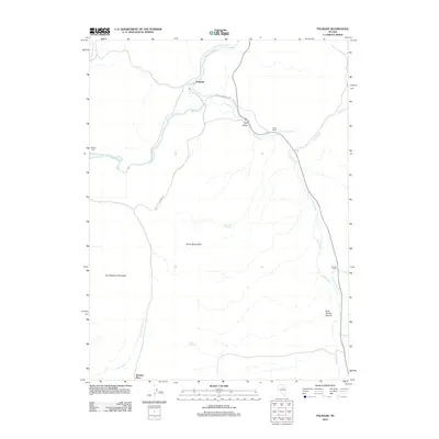
2012 Map of Palisade
USGS Topo · Published 2012About this map
Humboldt River corridor and its high desert surroundings are the focus of this study, documenting a region defined by scattered cattle ranches and rugged mountain ranges. The settlement of Palisade sits at a strategic point where the river meets the mouth of Pine Creek, illustrating the historical importance of water sources in the Great Basin. To the south, the Cortez Mountains and Iron Blossom Mountain dominate the skyline, while isolated homesteads such as Raine Ranch, Tomera Ranch, and Thomas Place are connected by utilitarian routes like the Rose Ranch-Beowawe road. The presence of Duggan Spur indicates the lingering infrastructure of the area's industrial past. Numerous water features, including Emigrant Spring and Rock Spring, highlight the essential landmarks once relied upon by travelers through this arid Nevada landscape.
Find a feature on this map
20 named features on this map. Tap any name to fly to it.
Don’t see what you’re looking for? This feature index may not catch every label — zoom into the map to look around manually.
Map Details
Editions of this 2012 Palisade Map
This is the sole edition of this map. No revisions or reprints were ever made.
Other maps of this area

1952 · Pine Valley
USGS Topo · 1:62,500

1952 · Carlin
USGS Topo · 1:62,500

1955 · Winnemucca
USGS Topo · 1:250,000

1957 · Frenchie Creek
USGS Topo · 1:62,500

1957 · Beowawe
USGS Topo · 1:62,500

1958 · Winnemucca
USGS Topo · 1:250,000

1962 · Winnemucca
USGS Topo · 1:250,000
1975 · Carlin NE
USGS Topo · 1:24,000

1985 · Scotts Gulch
USGS Topo · 1:24,000
1985 · Ravens Nest
USGS Topo · 1:24,000