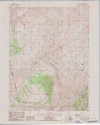
1985 Map of Ravens Nest
USGS Topo · Published 1986About this map
Pine Mountain dominates this high-elevation landscape in northeastern Nevada, where the border of Elko and Eureka counties traces a jagged line across the peaks. By the mid-1980s, the area's history as a mining district is clearly visible through a dense cluster of workings on the eastern slopes. A concentration of named claims including the Standing Elk Mine, Silver King Mine, and Red Bird Mine suggests a significant period of exploration and extraction near Lee Canyon. The topography is defined by sharp drainages like Ferdelford Creek and Webb Creek, which cut through the mountain front. Numerous water sources, such as Stump Spring and Murdock Spring, are crucial landmarks in this arid environment, while the eponymous Ravens Nest and Bunker Hill serve as primary navigational points for the high country.
Find a feature on this map
37 named features on this map. Tap any name to fly to it.
Don’t see what you’re looking for? This feature index may not catch every label — zoom into the map to look around manually.
Map Details
Editions of this 1985 Ravens Nest Map
This is the sole edition of this map. No revisions or reprints were ever made.
Other maps of this area

1934 · Jiggs
USGS Topo · 1:125,000

1937 · Jiggs
USGS Topo · 1:125,000

1952 · Dixie Flats
USGS Topo · 1:62,500

1952 · Pine Valley
USGS Topo · 1:62,500

1952 · Carlin
USGS Topo · 1:62,500

1955 · Winnemucca
USGS Topo · 1:250,000

1955 · Elko
USGS Topo · 1:250,000

1956 · Robinson Mtn
USGS Topo · 1:62,500

1958 · Winnemucca
USGS Topo · 1:250,000

1958 · Elko
USGS Topo · 1:250,000