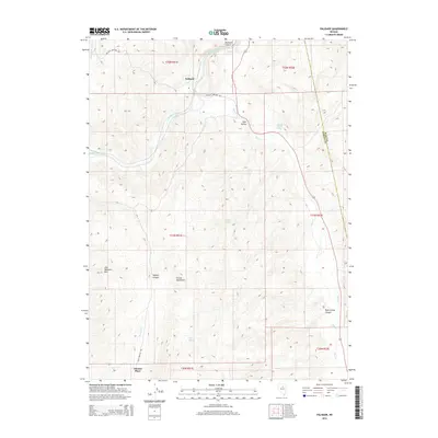
2014 Map of Palisade
USGS Topo · Published 2014About this map
Palisade serves as a central point of interest in this high-desert landscape where the Humboldt River carves through Palisade Canyon. The settlement pattern reflects the area's ranching and transit history, with named locations like Thomas Place situated along Thomas Cr and the specialized naming of Dann Frenchie Rd. The terrain is defined by the significant rise of Iron Blossom Mtn and the western edge of the Cortez Mountains, which overlook Pine Valley.
Find a feature on this map
25 named features on this map. Tap any name to fly to it.
Don’t see what you’re looking for? This feature index may not catch every label — zoom into the map to look around manually.
Map Details
Editions of this 2014 Palisade Map
This is the sole edition of this map. No revisions or reprints were ever made.
Other maps of this area

1952 · Pine Valley
USGS Topo · 1:62,500

1952 · Carlin
USGS Topo · 1:62,500

1955 · Winnemucca
USGS Topo · 1:250,000

1957 · Frenchie Creek
USGS Topo · 1:62,500

1957 · Beowawe
USGS Topo · 1:62,500

1958 · Winnemucca
USGS Topo · 1:250,000

1962 · Winnemucca
USGS Topo · 1:250,000
1975 · Carlin NE
USGS Topo · 1:24,000

1985 · Scotts Gulch
USGS Topo · 1:24,000
1985 · Ravens Nest
USGS Topo · 1:24,000