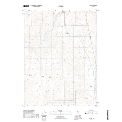
2018 Map of Palisade
USGS Topo · Published 2018About this map
The Humboldt River cuts through the northern reaches of this Eureka County landscape, flowing through the narrow Palisade Canyon near the settlement of Palisade. This area is defined by its dramatic elevation changes and essential water sources, including Raine Ranch Springs and Emigrant Spring, which historically supported movement through the Great Basin. To the south, the Cortez Mountains rise prominently, with Iron Blossom Mtn serving as a significant landmark overlooking the high desert terrain. The map details a network of canyons and drainages, such as Safford Canyon and Rock Spring Canyon, that feed into the broader Pine Valley. This modern survey traces the enduring connection between the river corridor and the remote ranching and mining country that characterizes this portion of Nevada, noting the junction of Eureka Co Elko Co as it follows the path of Pine Cr.
Find a feature on this map
25 named features on this map. Tap any name to fly to it.
Don’t see what you’re looking for? This feature index may not catch every label — zoom into the map to look around manually.
Map Details
Editions of this 2018 Palisade Map
This is the sole edition of this map. No revisions or reprints were ever made.
Other maps of this area

1952 · Pine Valley
USGS Topo · 1:62,500

1952 · Carlin
USGS Topo · 1:62,500

1955 · Winnemucca
USGS Topo · 1:250,000

1957 · Frenchie Creek
USGS Topo · 1:62,500

1957 · Beowawe
USGS Topo · 1:62,500

1958 · Winnemucca
USGS Topo · 1:250,000

1962 · Winnemucca
USGS Topo · 1:250,000
1975 · Carlin NE
USGS Topo · 1:24,000

1985 · Scotts Gulch
USGS Topo · 1:24,000
1985 · Ravens Nest
USGS Topo · 1:24,000