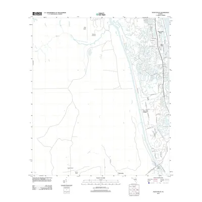
2012 Map of Palm Valley
USGS Topo · Published 2012About this map
Ponte Vedra Beach and Ponte Vedra stand as prominent coastal developments on this 2012 survey, separated from the interior by the winding waters of Cabbage Creek. The map documents a dense suburban corridor along the Atlantic coast, featuring a complex network of residential streets such as Solana Road and Dolphin Boulevard, while the west remains significantly more open. Large undeveloped areas like Scrub Ridge and Ragged Island suggest the low-lying, marshy character of the landscape near Pablo Creek and Box Branch. To the south, the settlement of Palm Valley Landing and the Palm Valley Bridge provide crucial access across the Intracoastal waterway. Further inland, specialized land uses appear at Deep Forest Airport and the Harbor City Municipal Golf Course, highlighting the region's mix of private aviation and recreation infrastructure amidst the expanding residential footprint.
Find a feature on this map
56 named features on this map. Tap any name to fly to it.
Don’t see what you’re looking for? This feature index may not catch every label — zoom into the map to look around manually.
Map Details
Editions of this 2012 Palm Valley Map
This is the sole edition of this map. No revisions or reprints were ever made.
Other maps of this area

1917 · Orange Park
USGS Topo · 1:62,500

1918 · Jacksonville
USGS Topo · 1:62,500

1918 · Orange Park
USGS Topo · 1:62,500

1918 · Palm Valley
USGS Topo · 1:62,500

1918 · Mayport
USGS Topo · 1:62,500

1948 · Jacksonville
USGS Topo · 1:250,000

1948 · Jacksonville Beach
USGS Topo · 1:24,000

1949 · Jacksonville Beach
USGS Topo · 1:24,000

1950 · Arlington
USGS Topo · 1:24,000
1952 · Orangedale
USGS Topo · 1:24,000