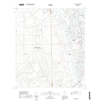
2018 Map of Palm Valley
USGS Topo · Published 2018About this map
The Intracoastal Waterway serves as a defining meridian for this part of coastal Florida, separating the dense residential developments of Ponte Vedra Beach and Palm Valley from the extensive wetlands to the west. On the eastern shore, a complex network of residential streets like Solana Rd and Dolphin Blvd reflects the suburban growth near the Atlantic Ocean. In contrast, the western landscape is dominated by the vast Durbin Swamp and Scrub Ridge, showcasing the region's natural hydrology before it reaches Pablo Creek. Small, distinct nodes of activity appear along the water, including the Palm Valley Landing and the Deep Forest-Airport. This 2018 survey also identifies the southern reaches of Jacksonville and the settlement of Twentymile, documenting the persistent tension between expanding coastal infrastructure and the swampy lowlands of the Cabbage Swamp and Powers Bay.
Find a feature on this map
82 named features on this map. Tap any name to fly to it.
Don’t see what you’re looking for? This feature index may not catch every label — zoom into the map to look around manually.
Map Details
Editions of this 2018 Palm Valley Map
This is the sole edition of this map. No revisions or reprints were ever made.
Other maps of this area

1917 · Orange Park
USGS Topo · 1:62,500

1918 · Jacksonville
USGS Topo · 1:62,500

1918 · Orange Park
USGS Topo · 1:62,500

1918 · Palm Valley
USGS Topo · 1:62,500

1918 · Mayport
USGS Topo · 1:62,500

1948 · Jacksonville
USGS Topo · 1:250,000

1948 · Jacksonville Beach
USGS Topo · 1:24,000

1949 · Jacksonville Beach
USGS Topo · 1:24,000

1950 · Arlington
USGS Topo · 1:24,000
1952 · Orangedale
USGS Topo · 1:24,000