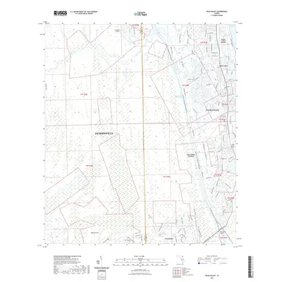
2021 Map of Palm Valley
USGS Topo · Published 2021About this map
Palm Valley and the Atlantic coastline of Ponte Vedra Beach define this stretch of northeast Florida where suburban expansion meet preserved wetlands. The Intracoastal Waterway cuts through the landscape, separating the developed coastal communities from the dense interiors of Cabbage Swamp and Durbin Swamp. The map details a transition from the structured residential grids of Ponte Vedra to the more open, traditional settlements like Twentymile and Palm Valley Landing. Outdoor recreation is prominent along the Florida Circumnavigational Paddling Trail, which follows the waterways past Ragged Island and through Powers Bay. This survey captures the county line between Duval County and St. Johns County, showing how the outskirts of Jacksonville interface with the drainage systems of Pablo Creek and Cabbage Creek.
Find a feature on this map
98 named features on this map. Tap any name to fly to it.
Don’t see what you’re looking for? This feature index may not catch every label — zoom into the map to look around manually.
Map Details
Editions of this 2021 Palm Valley Map
This is the sole edition of this map. No revisions or reprints were ever made.
Other maps of this area

1917 · Orange Park
USGS Topo · 1:62,500

1918 · Jacksonville
USGS Topo · 1:62,500

1918 · Orange Park
USGS Topo · 1:62,500

1918 · Palm Valley
USGS Topo · 1:62,500

1918 · Mayport
USGS Topo · 1:62,500

1948 · Jacksonville
USGS Topo · 1:250,000

1948 · Jacksonville Beach
USGS Topo · 1:24,000

1949 · Jacksonville Beach
USGS Topo · 1:24,000

1950 · Arlington
USGS Topo · 1:24,000
1952 · Orangedale
USGS Topo · 1:24,000